Hike Through the Tsingy
Follow marked routes through or around the limestone formations
and discover one of Madagascar’s most distinctive karst landscapes.
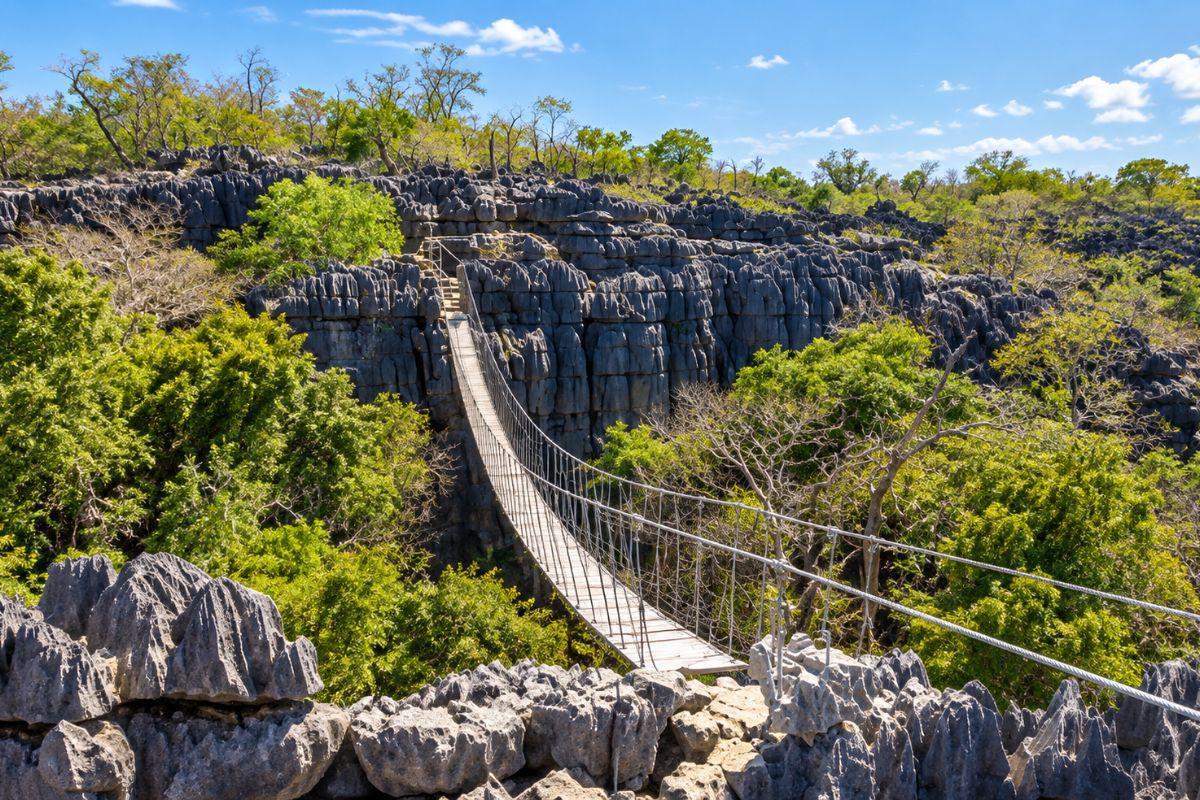
Located between Antsiranana and the Nosy Be region, Ankarana is particularly
rewarding for travellers who enjoy hiking, geology, wildlife and landscapes
that feel completely different from Madagascar’s rainforests and beaches.
It fits naturally into a journey through
Northern Madagascar
and combines especially well with
Amber Mountain
,
Antsiranana
and
Nosy Be
.
Ankarana is one of the best places in Madagascar to experience the strange
limestone landscapes known locally as tsingy.
The massif has been shaped over immense periods of time by water dissolving
and cutting through limestone. The result is a complex landscape of sharp pinnacles,
narrow passages, caves, canyons and underground drainage systems.
But Ankarana is not only about geology. Dry forest grows around and between
the limestone formations, providing habitat for lemurs, birds, reptiles,
bats and many endemic plants.
This combination of geology, wildlife and hiking is what makes the reserve
so rewarding for adventurous travellers.
Ankarana is officially classified as a Special Reserve and is managed by
Madagascar National Parks together with local communities.
Madagascar National Parks gives the reserve an area of 18,225 hectares
and describes its principal landscapes as tsingy, limestone canyons,
labyrinthine caves and dry forest.
The protected area lies in the DIANA region between the areas of
Antsiranana and Ambilobe, making it a natural stop on an overland journey
through northern Madagascar.
Sources & Reserve Information
Size, access, biodiversity and visitor information on this page are based
primarily on Madagascar National Parks, the official manager of Ankarana Special Reserve.
Ankarana is part of one of Madagascar’s major internationally recognised
dry-forest conservation landscapes.
Since 2023, Ankarana Special Reserve has formed part of the UNESCO
World Heritage property known as the Andrefana Dry Forests.
This is a serial natural property combining six protected areas
across western and northern Madagascar.
UNESCO recognises the property for its exceptional dry-forest biodiversity,
evolutionary history and spectacular karst landscapes.
Ankarana contributes both its dry forest ecosystems and its remarkable
limestone formations to this wider World Heritage property.
Authoritative source
Read more on the
official UNESCO page for the Andrefana Dry Forests
.
Tsingy are spectacular limestone formations shaped by erosion into sharp
ridges, pinnacles and narrow corridors.
In Ankarana, these formations create a landscape that can resemble a stone forest.
Paths may pass beside limestone walls, through narrow passages or towards
viewpoints overlooking fields of grey rock.
The geological landscape is closely connected with the caves and underground
waterways beneath the massif.
This combination makes Ankarana one of the most visually unusual destinations
in northern Madagascar.
Ankarana is primarily an active destination, with hiking and guided
exploration at the centre of the experience.
Follow marked routes through or around the limestone formations
and discover one of Madagascar’s most distinctive karst landscapes.
Ankarana contains an extensive network of caves and underground
passages created by water moving through the limestone massif.
Deep canyons cut through the limestone and create sheltered habitats
where vegetation can contrast sharply with the exposed tsingy above.
Dry forest and canyon habitats support several lemur species,
making wildlife observation an important part of guided hikes.
Madagascar National Parks lists birdwatching among the official
visitor activities available in the reserve.
Combine Ankarana’s dry forest and limestone with rainforest,
beaches and islands elsewhere in the north.
One of the most fascinating aspects of Ankarana lies beneath the surface.
Water has carved extensive cave systems through the limestone massif.
Madagascar National Parks specifically highlights the reserve’s
labyrinthine caves as one of its defining natural features.
Guided caving experiences can reveal chambers, passages and geological
formations hidden beneath the dry forest above.
Cave exploration should always be undertaken with appropriate local guidance.
Conditions, accessibility and permitted routes can vary, and some areas
may have cultural or ecological sensitivity in addition to physical hazards.
At first glance, the limestone formations dominate the landscape.
But the forests around and within Ankarana are just as important.
Madagascar National Parks records dense dry forest, canyon forest and riparian
forest within the reserve.
Official park information records hundreds of plant species and a very high
level of endemism, including species found only in Ankarana.
This explains why a hike can move quickly between exposed limestone,
dry woodland and greener canyon vegetation.
Wildlife observation adds another layer to the geological experience.
Several lemur species inhabit the forest environments of Ankarana,
and patient guided walks can provide opportunities to observe them.
The reserve’s extensive cave systems provide important habitats
for bat populations.
Dry forest, rock and cave environments support a variety of reptiles,
including species that can be difficult to detect without local knowledge.
Birdwatching is one of the activities officially promoted by
Madagascar National Parks within Ankarana.
The reserve supports highly diverse dry-forest vegetation and
a significant number of endemic plant species.
Sheltered canyons create cooler and greener microhabitats that can
support species different from those found on exposed limestone.
Ankarana feels more adventurous than many conventional wildlife reserves.
A visit may involve hiking over uneven terrain, walking beside limestone
pinnacles, entering caves and moving through dry forest in warm conditions.
The reward is variety. In a relatively compact region you can experience
striking geology, forest, wildlife and underground landscapes.
This makes Ankarana particularly memorable when combined with the cool
rainforest of Amber Mountain, because the two protected areas feel completely different.
Access within Ankarana varies according to the part of the reserve and the season.
Madagascar National Parks states that the eastern visitor zone,
accessed from the reception office at Mahamasina, is open throughout the year.
This makes it the most straightforward part of the reserve to integrate
into many northern Madagascar itineraries.
According to Madagascar National Parks, the western ecotourism zone
is generally accessible from July to November from Andrafiabe.
Access conditions should still be confirmed locally before travel,
particularly after significant rainfall.
Hiking is the main way to experience the reserve’s tsingy,
forest and canyon landscapes.
Madagascar National Parks officially lists caving among
the activities available within the reserve.
Guided nature excursions and birdwatching provide opportunities
to focus on the reserve’s biodiversity as well as its geology.
Combine dry limestone landscapes with cool mountain rainforest,
waterfalls and endemic wildlife.
Add the bays, beaches and landscapes of Madagascar’s far north
to your Ankarana journey.
Continue towards tropical beaches, marine excursions and island life
after exploring northern Madagascar’s mainland reserves.
Add a quieter island experience with forest, villages and coastal scenery.
Ankarana sits naturally between the Antsiranana region and the route towards Nosy Be.
A particularly varied northern itinerary can combine Antsiranana and Amber Mountain,
continue through Ankarana and then finish with time on Nosy Be or Nosy Komba.
This sequence creates a remarkable change of scenery: bays and dry northern
landscapes, cool rainforest, limestone tsingy and finally tropical islands.
Madagascar National Parks indicates that the reserve is reached by road
via the RN6.
The Mahamasina reception area is around 30 km from Ambilobe and
approximately 108 km from Antsiranana according to official park information.
A single day can provide an introduction, but travellers interested
in several hikes, caves or different parts of the reserve benefit
from allowing more time.
Good walking shoes are essential. Sun protection, water,
lightweight clothing and a small daypack are also useful.
For cave visits, follow your guide’s recommendations regarding
lighting and appropriate equipment.
Guided visits are strongly recommended for understanding the terrain,
locating wildlife and safely exploring the reserve’s more complex routes.
The eastern visitor zone is listed by Madagascar National Parks as accessible
throughout the year.
The western ecotourism zone has a more limited season, with official park
information indicating access generally from July to November.
Seasonal rainfall can affect trail and road conditions, so current access
should always be confirmed when planning the trip.
Madagascar National Parks states that Ankarana is managed in cooperation
with local communities through local park committees.
This local involvement forms part of the reserve’s wider conservation
and development strategy.
Stay on authorised routes, follow guide instructions, avoid disturbing
wildlife and never remove rocks, plants or other natural material.
Supporting authorised guides and local services also helps tourism
contribute more directly to the surrounding communities.
Yes, especially for travellers interested in hiking, geology, caves,
wildlife and unusual landscapes. It is one of the most distinctive
protected areas in northern Madagascar.
Ankarana is famous for its tsingy limestone formations, caves,
canyons, dry forest and endemic biodiversity.
Ankarana Special Reserve is one of the six protected areas that form
the UNESCO World Heritage property known as the Andrefana Dry Forests.
Ankarana was added as part of the major extension approved in 2023.
Yes. Madagascar National Parks lists caving among the official activities
available in the reserve. Access depends on the route, conditions and local guidance.
The eastern ecotourism zone is officially accessible year-round,
while the western zone is generally accessible from July to November.
Current conditions should still be checked before travel.
Yes. Combining
Ankarana
with
Amber Mountain
is one of the best ways to experience two contrasting ecosystems
in northern Madagascar.
Yes. Ankarana fits naturally into an overland journey towards
Nosy Be
,
allowing you to combine hiking and wildlife with island and beach time.
Ankarana combines razor-sharp tsingy, caves, canyons, dry forest and wildlife
in one of northern Madagascar’s most adventurous landscapes. Natura Travel can
integrate the reserve into a private itinerary combining Antsiranana,
Amber Mountain and the islands around Nosy Be.