Explore Lokaro Bay
Travel through lagoons and coastal landscapes to one of the region’s
most beautiful bays, known for white sand, turquoise water and hiking.
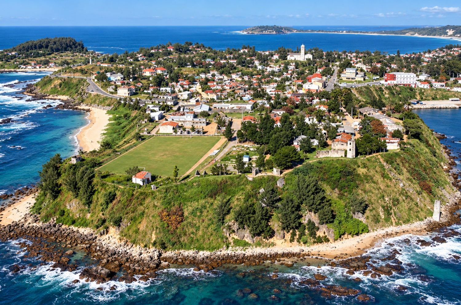
The city and surrounding Anôsy region offer an unusual combination of
beaches, tropical vegetation, dry southern landscapes, wildlife,
history and local culture.
Travellers can explore the coast around Lokaro, visit the botanical landscapes
of Nahampoana, hike above the city, continue towards Andohahela National Park
or head west towards the wildlife and spiny forest environments around Berenty.
Fort Dauphin therefore works particularly well as a destination in its own right
or as the starting point for a deeper journey through
Southern Madagascar
.
Fort Dauphin is one of those Madagascar destinations where several
completely different landscapes meet within a relatively small region.
To the east lies the Indian Ocean and a coastline of beaches and rocky bays.
Inland are lagoons, humid vegetation and mountain landscapes, while travelling
west leads progressively into the much drier ecosystems of southern Madagascar.
This ecological transition creates exceptional variety for travellers.
A journey can combine swimming, hiking, lemurs, botanical gardens,
rainforest, spiny forest and cultural experiences without repeating
the same type of scenery every day.
Fort Dauphin also has an important historical identity and acts as the
regional centre of Anôsy, making it more than simply a beach destination.
Fort Dauphin is the principal city of the Anôsy region in Madagascar’s
extreme southeast.
Madagascar’s National Tourism Board presents the destination as a meeting
point between humid and dry biodiversity, highlighting beaches, scenery,
lemurs, palms, tropical plants, history and culture.
Recent official tourism programmes include excursions to Nahampoana,
Lokaro and Evatra, as well as journeys towards Berenty.
This diversity is one of the strongest reasons to spend several days
in the region rather than treating Fort Dauphin only as a transport hub.
Sources & Local Context
Information about Fort Dauphin’s major nature excursions and the contrast
between humid and dry ecosystems is supported by recent programmes
published by Madagascar’s National Tourism Board.
The strongest itinerary combines the city and coast with excursions
into the remarkable landscapes of the wider Anôsy region.
Travel through lagoons and coastal landscapes to one of the region’s
most beautiful bays, known for white sand, turquoise water and hiking.
Discover tropical vegetation and wildlife in a botanical setting
close to Fort Dauphin.
Enjoy one of the city’s most accessible beaches, used for swimming,
coastal walks and surfing when conditions allow.
Climb above Fort Dauphin for panoramic views over the city,
mountains, lagoons and Indian Ocean coastline.
Discover one of Madagascar’s most ecologically diverse national parks,
where humid eastern forest transitions toward the dry south.
Use Fort Dauphin as a base for exploring the distinctive wildlife,
culture and landscapes of Madagascar’s far south.
Lokaro is one of the signature excursions from Fort Dauphin.
Madagascar’s National Tourism Board describes Lokaro as one of the
most popular tourism circuits in southern Madagascar.
The bay is known for white-sand beaches, turquoise water and
panoramic coastal views.
Official itineraries commonly combine boat travel on the waterways
around Lanirano with a walk from the fishing village of Evatra
towards Lokaro.
This makes the excursion interesting not only for the beach,
but also for the journey through lagoons and local landscapes.
Current visitor information
Madagascar’s National Tourism Board reported that Lokaro’s visitor facilities
were recently improved, with new amenities intended to support both tourism
and surrounding communities.
Official tourism information lists several possible activities around Lokaro,
including swimming, snorkeling, trekking, surfing and time on the beach.
One of the strongest aspects of the excursion is the variety of landscapes:
river and lagoon environments, fishing villages, green hills and open coast.
Sea and weather conditions can change, so swimming or snorkeling should
always be based on current local advice rather than assumed to be suitable
every day.
Nahampoana offers an accessible introduction to the flora and fauna
of southeast Madagascar close to Fort Dauphin.
Recent programmes from Madagascar’s National Tourism Board describe
Nahampoana as a botanical garden showcasing the plant life
characteristic of the humid southeast.
The setting makes it useful for travellers who want a gentler
nature experience without a demanding expedition.
Lemurs are among the animals associated with the site,
alongside a variety of tropical plants and smaller wildlife.
As with any animal encounter, observation should take priority
over feeding, touching or staging photographs.
The coastline is a major part of Fort Dauphin’s appeal.
Libanona lies close to the city and is one of Fort Dauphin’s
best-known beaches for relaxation, swimming and surfing.
Lokaro offers a more remote coastal experience reached as part
of a longer excursion through waterways and villages.
The wider coastline includes exposed beaches, rocky headlands
and dramatic views over the Indian Ocean.
Sea conditions
Parts of the southeastern coast can experience strong surf and currents.
Always follow current local advice before swimming or surfing.
Pic Saint Louis rises above Fort Dauphin and provides one of the most
impressive panoramic viewpoints in the region.
Madagascar’s National Tourism Board gives the summit an elevation
of approximately 529 metres.
From above, hikers can appreciate the geography that makes Fort Dauphin
so unusual: ocean, bays, lakes, green lowlands and mountain chains
all visible within the same panorama.
The hike is particularly interesting for landscape photographers
and travellers who want to understand how the wet southeast transitions
towards the drier interior.
Andohahela is one of the most ecologically unusual national parks
in Madagascar.
Madagascar National Parks gives Andohahela a total area
of 76,140 hectares.
The park contains mountain rainforest, transitional vegetation,
dry savanna and characteristic southern thorny vegetation.
Madagascar National Parks describes Andohahela as the only protected
area in Madagascar representing the junction between the humid
forests of the east and the arid landscapes of the south.
This ecological transition makes it especially valuable for travellers
interested in understanding Madagascar’s biodiversity at a landscape scale.
Authoritative source
Learn more from
Madagascar National Parks’ official Andohahela page
.
Madagascar National Parks records 14 species of lemurs within Andohahela,
including ring-tailed lemurs, sifakas, collared brown lemurs,
southern bamboo lemurs and aye-ayes.
The park also protects remarkable plant life, including the distinctive
triangle palm, Dypsis decaryi, one of the botanical symbols
of southern Madagascar.
Because habitats differ greatly from one part of the park to another,
the wildlife experience depends strongly on the circuit chosen.
The humid forest of Andohahela’s Parcel I forms part of the serial
UNESCO World Heritage property known as the Rainforests of the Atsinanana.
The wider World Heritage property protects some of Madagascar’s
most important remaining eastern rainforest ecosystems.
It is important to be precise: not all of Andohahela is within
the UNESCO property.
The World Heritage component relates specifically to the humid
forest section included within the serial Rainforests of the Atsinanana site.
Fort Dauphin is also a common gateway for journeys towards Berenty,
further west in the drier landscapes of southern Madagascar.
Madagascar’s National Tourism Board highlights Berenty for its
sifakas, ring-tailed lemurs, reptiles, birds and characteristic
southern vegetation.
The environment provides a dramatic contrast with Fort Dauphin’s
greener coastal landscapes.
Journeys through this region can also introduce travellers
to the history, traditions and daily life of southern communities.
This makes the route interesting not only for wildlife but also
for understanding the cultural geography of southern Madagascar.
Fort Dauphin has a long maritime and colonial history linked to Madagascar’s
southeast coast and early European activity on the island.
Madagascar’s tourism authorities continue to present history and culture
as important parts of the city’s visitor experience, alongside its natural sites.
Museums and historical sites in the wider Anôsy region provide opportunities
to learn more about Antanosy and Antandroy traditions as well as the area’s
colonial past.
Travellers interested in culture should avoid reducing the region to
its colonial history alone. The living traditions of the communities
of Anôsy and the wider south are equally important to understanding the destination.
One of the most fascinating features of the Fort Dauphin region is
the speed at which landscapes change.
Moisture from the Indian Ocean supports green vegetation and humid forest
east of the mountain barriers.
Travelling inland and westward, conditions become progressively drier,
leading towards the thorny ecosystems associated with southern Madagascar.
Few places on the island make this ecological transition as easy to appreciate
within a single regional journey.
Fort Dauphin provides access to beaches, botanical sites,
rainforest, dry habitats and wildlife within one wider region.
Hiking, coastal walks, boat excursions and national park visits
make it suitable for travellers who prefer active days.
The history of Fort Dauphin and the cultures of the Anôsy region
add depth to a journey that might otherwise focus only on nature.
Fort Dauphin is remote enough that it should normally be treated as a
substantial part of the itinerary rather than a rushed side trip.
A regional journey can combine the city and beaches with Nahampoana,
Lokaro, Andohahela and Berenty, creating a route through very different
ecological and cultural environments.
Travellers with more time can then connect this southeastern journey
with other parts of southern Madagascar according to transport
conditions and available routes.
Air travel is commonly used to reach Fort Dauphin because of
the long and challenging overland distances involved.
Flight schedules can change, so connections should be verified
when the itinerary is booked rather than based on old timetables.
Fort Dauphin deserves several days if you want to include
Lokaro, Nahampoana, beaches and regional nature excursions.
Adding Andohahela or Berenty requires additional time
because each involves its own road logistics and activities.
Conditions in southeastern Madagascar differ from the dry southwest,
so the ideal season depends on your full itinerary.
Madagascar National Parks states that Andohahela can be visited
year-round, with June to November particularly favourable
for wildlife observation.
Sun protection, rain protection, insect repellent and good
walking shoes are useful because activities may range from
beaches to humid forest and mountain trails.
Waterproof protection for cameras and electronics is also useful
for boat and coastal excursions.
Excursions to places such as Lokaro pass through villages
and landscapes where tourism forms part of the local economy.
Using local guides, purchasing local products and respecting
community rules helps more of the value of tourism remain in the region.
Southeastern Madagascar contains sensitive rainforest,
coastal and transitional habitats.
Stay on authorised trails, avoid feeding wildlife,
follow protected-area rules and minimise disturbance
in both terrestrial and marine environments.
Explore one of Madagascar’s most unusual ecological transitions,
from humid forest to dry southern habitats.
Add ring-tailed lemurs, sifakas and the spiny vegetation
of Madagascar’s drier south.
Combine southeastern Madagascar with sandstone canyons,
hiking and the dramatic landscapes of the RN7.
Add the dry southwest, spiny forest and Mozambique Channel coastline
for another completely different Madagascar environment.
Yes. Fort Dauphin is particularly interesting for travellers
who want to combine beaches, mountains, wildlife, history
and access to several contrasting ecosystems.
Fort Dauphin is known for its dramatic coastal setting,
beaches, Lokaro Bay, Nahampoana, regional wildlife
and its historical and cultural importance within Anôsy.
Yes. Lokaro is one of the signature excursions from Fort Dauphin,
combining boat travel, fishing villages, walking, white-sand beaches
and turquoise coastal scenery.
Yes. Fort Dauphin is the principal gateway for visiting
Andohahela National Park, although access depends on the chosen
park circuit and current road conditions.
Depending on the site, visitors may encounter lemurs,
sifakas, birds, reptiles and endemic plant life.
Andohahela alone is reported by Madagascar National Parks
to protect 14 lemur species.
Yes. Fort Dauphin is commonly used as the gateway for journeys
towards Berenty, where visitors can experience lemurs,
spiny vegetation and the drier landscapes of southern Madagascar.
Yes. Libanona is one of the most accessible beaches close to town,
while Lokaro offers a more remote beach and coastal excursion.
Several days are recommended if you want to experience the city,
beaches, Nahampoana and Lokaro. Additional time is needed for
Andohahela or Berenty.
Fort Dauphin combines beaches, mountains, tropical vegetation,
wildlife and culture in one of Madagascar’s most geographically
distinctive regions. Natura Travel can integrate the destination
into a private journey with realistic time for Lokaro, Nahampoana,
Andohahela, Berenty and the wider landscapes of the southeast.