Climb Pic Boby
Take on Andringitra’s best-known trek and climb through changing
vegetation zones towards the 2,658-metre summit.
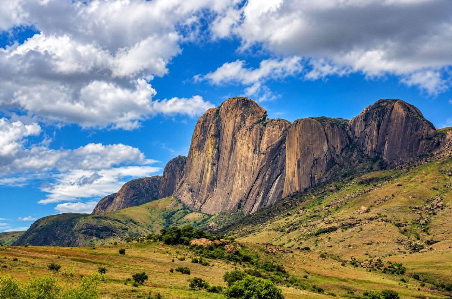
The park is especially known for trekking and for Imarivolanitra, commonly
called Pic Boby, which rises to 2,658 metres and is one of Madagascar’s most
iconic accessible summits.
Andringitra is also much more than a mountain challenge. Its extraordinary
range of elevations creates rainforest, high-altitude grasslands, rocky moorland,
waterfalls and habitats for lemurs, birds, reptiles and endemic plants.
The park fits naturally into a journey through
Southern Madagascar
,
particularly when combined with
Ambalavao
and
Isalo National Park
.
Andringitra is one of Madagascar’s strongest destinations for travellers
who want to experience the island on foot.
The scenery is unusually varied. Granite domes and cliffs rise above valleys,
while the eastern side of the massif supports humid forest and the higher
elevations open into grasslands, rocky plateaus and alpine-like landscapes.
The park’s altitude also creates a climate unlike much of southern Madagascar.
Conditions can become cold at night, especially on high-altitude treks.
For travellers who enjoy hiking, photography, wildlife and a sense of
wilderness, Andringitra can be one of the most memorable stops on the RN7 route.
Madagascar National Parks gives Andringitra National Park a surface area
of 31,160 hectares across the Haute Matsiatra and Ihorombe regions.
The protected landscape includes granite peaks, cliffs, valleys,
dense humid forests, mountain vegetation, grasslands and savannas.
This extraordinary variation in altitude creates a succession of microclimates
and ecosystems, which explains the park’s rich biodiversity.
Madagascar National Parks records at least 10 species of lemurs and more
than 100 endemic plant species within Andringitra.
Sources & Park Information
Information about Andringitra’s area, habitats, Pic Boby, biodiversity,
trails and access is based primarily on Madagascar National Parks,
the official manager of the protected area.
The ascent of Pic Boby is one of the most famous treks in Madagascar.
Madagascar National Parks lists Imarivolanitra, commonly known
as Pic Boby, at an altitude of 2,658 metres.
The summit offers expansive views across the mountain landscape
and gives trekkers access to some of the park’s distinctive
high-altitude habitats.
The official Imarivolanitra circuit involves approximately
28 kilometres return, or a 23-kilometre loop when combined
with the Diavolana route.
Madagascar National Parks describes the ascent as a two-day
walking itinerary, so it should not be approached as a quick
roadside excursion.
Mountain conditions
Weather can change quickly at altitude. Temperatures may fall well below
freezing during the cooler season, so appropriate clothing, camping
equipment and realistic preparation are essential.
Andringitra National Park forms part of the UNESCO World Heritage property
known as the Rainforests of the Atsinanana.
This serial natural property was inscribed in 2007 and includes six
national parks protecting some of the most important remaining humid
forests of eastern Madagascar.
UNESCO recognises these forests for their exceptional ecological processes,
extraordinary levels of endemism and globally important biodiversity.
The Andringitra component contributes more than 32,000 hectares to the
UNESCO property, protecting habitats that range from humid forest
to montane ecosystems.
Authoritative source
Learn more from the
UNESCO World Heritage Centre page for the Rainforests of the Atsinanana
.
Trekking is the main reason to come, but the park offers several
very different mountain and forest experiences.
Take on Andringitra’s best-known trek and climb through changing
vegetation zones towards the 2,658-metre summit.
Explore a striking high-altitude landscape of rock formations,
open terrain and mountain vegetation.
Discover two culturally important waterfalls on the Asaramanitra
circuit, surrounded by forest and mountain scenery.
Forest circuits provide opportunities to search for several
lemur species as well as endemic birds and reptiles.
Multi-day routes use designated campsites that allow travellers
to experience Andringitra’s mountain atmosphere after day visitors leave.
Combine Andringitra with Ambalavao, Isalo and the wider RN7 route.
Madagascar National Parks maintains several official circuits,
ranging from shorter walks to demanding multi-day routes.
A moderate route of around 6 kilometres and approximately four
hours, featuring the Riandahy and Riambavy waterfalls,
forest, orchids and viewpoints.
A more demanding high-altitude route through unusual rocky landscapes
and mountain vegetation.
The classic Pic Boby ascent, officially described as a two-day
trekking route.
A forest-focused route offering opportunities to observe lemurs,
birds and dense vegetation.
A longer route towards the western plateau, with high-altitude
palms, open landscapes and a natural pool.
Longer combinations can connect several circuits and campsites,
creating a deeper exploration of the massif.
Andringitra’s greatest strength is the rapid change in landscapes
as elevation increases.
Madagascar National Parks describes dense humid forest at lower and
middle elevations, mountain sclerophyllous forest, high-altitude grasslands,
savannas, rocky moorland and mountain thickets.
This means that a trek through Andringitra can feel like travelling
through several different ecological regions within the same park.
The visual contrast between forested valleys and exposed granite
summits is one of the defining features of the destination.
Although Andringitra is famous for mountains, its biodiversity
is just as important as its scenery.
Madagascar National Parks records at least 10 lemur species,
including ring-tailed lemurs, Milne-Edwards’ sifakas
and bamboo lemurs.
Mountain forests and high-altitude habitats support a rich
bird community, including endemic species.
Chameleons, geckos and frogs occur across the park’s different
ecological zones.
Andringitra protects rare orchids, palms and other plants
adapted to mountain environments.
Madagascar National Parks records more than 100 endemic plant
species within the protected area.
Rocky plateaus and montane vegetation create habitats rarely
experienced on conventional Madagascar itineraries.
The park is not isolated from the human landscapes surrounding it.
Villages around Andringitra form part of the cultural landscape
of the southern Highlands.
Madagascar National Parks includes village visits among the
experiences available around the park, providing opportunities
to learn more about Betsileo traditions.
Village visits should be approached as cultural encounters,
not as attractions staged solely for visitors.
Follow local guidance, ask before photographing people
and respect community customs.
Andringitra is very different from visiting a national park by vehicle.
The experience is built around walking, changing weather,
altitude and time spent outdoors.
Trails can involve long days, steep sections and significant temperature
changes between valley floors and high-altitude campsites.
The reward is a level of immersion that is difficult to achieve on
shorter wildlife excursions: evenings in the mountains, open horizons,
quiet camps and landscapes that change throughout the day.
Travellers considering Pic Boby should therefore think of Andringitra
as a genuine trekking destination rather than simply another stop
on the RN7.
Madagascar National Parks states that access becomes difficult
during the rainy season, generally from November to March.
Tracks leading towards the park can become challenging,
which is important when planning transfers from Ambalavao.
From April to September, high-altitude temperatures can fall
well below 0°C.
This is especially relevant for the ascent of Imarivolanitra,
which requires at least one night at altitude.
Plan for the whole itinerary
The best travel period should also consider Ambalavao, Isalo
and the other destinations in your southern Madagascar route.
See our
guide to the best time to visit Madagascar
.
Madagascar National Parks lists Ambalavao as one of the main
gateways to Andringitra.
The Namoly entrance is approximately 47 kilometres from Ambalavao
along a track that can be difficult during the rainy season.
Another park entrance lies at Morarano, approximately 60 kilometres
from the RN7 turn-off according to Madagascar National Parks.
A four-wheel-drive vehicle is strongly recommended for park access,
especially when road conditions are poor.
Practical advice
Do not plan transfer times from old reports alone. Track conditions
can vary significantly with rainfall, so current access should be
confirmed shortly before travel.
Camping is an important part of the Andringitra experience,
particularly for multi-day trekking.
Madagascar National Parks lists several designated campsites,
including Belambo, Andranolava, Andriampotsy and Iantaranomby.
Facilities remain relatively simple, which is part of the park’s
wilderness character.
Trekkers should arrive prepared for mountain weather and make sure
that food, water arrangements, bedding and equipment are planned
according to the chosen route.
Andringitra is one of Madagascar’s strongest destinations
for serious hiking and multi-day mountain trekking.
Granite peaks, valleys, waterfalls and high-altitude landscapes
provide some of southern Madagascar’s most dramatic scenery.
Forest, endemic wildlife and unusual montane ecosystems make
the park valuable even for travellers who are not attempting Pic Boby.
Combine Andringitra with crafts, Betsileo culture,
Anja Reserve and ring-tailed lemurs.
Add historic architecture and Highland culture before
continuing south towards Ambalavao and Andringitra.
Combine mountain trekking with humid rainforest and
wildlife watching.
Continue south for sandstone massifs, canyons,
natural pools and much drier scenery.
Finish an active RN7 itinerary with coastal landscapes
and the dry southwest.
Andringitra works best when treated as a major experience rather than
squeezed into a single rushed day.
A classic route can travel from Fianarantsoa to Ambalavao,
spend time around Anja and Andringitra, then continue south
towards Isalo and the southwest.
This creates one of Madagascar’s most varied journeys,
moving from Highland culture and rainforest to granite mountains,
dry plateaus, sandstone canyons and eventually the coast.
The right length depends on the trail you choose.
Shorter circuits can be completed in a day, while Pic Boby
and more ambitious combinations require multiple days
including camping.
Guided visits are the appropriate way to explore the park,
especially for long mountain routes.
A local guide helps with navigation, wildlife observation,
cultural context and changing trail conditions.
Proper hiking footwear, warm layers, rain protection,
sun protection and sufficient water capacity are essential.
For overnight routes, camping and sleeping equipment
should be suited to potentially freezing mountain temperatures.
Andringitra offers routes of different difficulty levels,
but Pic Boby and longer circuits require a good level
of hiking fitness.
The combination of altitude, long walking days and uneven
terrain is more important than technical mountaineering ability.
Madagascar National Parks identifies pressures including
vegetation fires, land clearing, resource exploitation
and livestock entering sensitive habitats.
These threats are especially important because many species
and plant communities are adapted to narrow ecological zones.
Current park management includes work with surrounding communities,
awareness programmes, reforestation and projects intended
to support more sustainable livelihoods.
Using authorised guides and respecting campsites and trail rules
helps tourism contribute to this conservation model.
Yes, especially for travellers interested in hiking, mountains,
dramatic landscapes and a more adventurous Madagascar experience.
Madagascar National Parks gives the altitude of Imarivolanitra,
commonly known as Pic Boby, as 2,658 metres.
The official Imarivolanitra circuit is normally organised as
a two-day trek, with at least one night spent at altitude.
Andringitra National Park forms part of the serial UNESCO World Heritage
property known as the Rainforests of the Atsinanana, inscribed in 2007.
Yes. Madagascar National Parks warns that temperatures at altitude
can fall well below 0°C between April and September.
The park is usually accessed from the RN7 near
Ambalavao
,
followed by mountain tracks towards entrances such as Namoly.
Yes. Ambalavao is one of the natural gateways to Andringitra,
and combining the two provides a strong mix of culture,
ring-tailed lemurs and mountain trekking.
Yes. Travellers commonly continue south towards
Isalo National Park
,
creating a striking contrast between granite mountains
and sandstone canyons.
Andringitra combines some of Madagascar’s most dramatic mountain scenery
with serious trekking, endemic wildlife and a UNESCO-listed natural landscape.
Natura Travel can integrate the park into a private southern Madagascar
itinerary with realistic time for access, hiking, camping and recovery.